Earthwork Tool User Guide

Overview
The Earthwork Tool helps you easily perform earthwork cut and fill volume calculations, including region-based volume calculations, considering topsoil stripping and subgrade base layers. It’s your solution for construction earthwork workflows, built for accuracy and speed.
Key Features:
- Full Volume Surface - Complete surface comparison between surfaces for cut/fill calculations.
- Region Volume Surfaces - Multiple region-based cut/fill calculations with defined boundaries.
- Topsoil Stripping Layer - Includes Topsoil Stripping surfaces consideration with configurable depth.
- Subgrade Base Layer - Includes Subgrade base layer consideration with configurable depth for defined regions.
- Dynamic Volume Units - Switch between m³, yd³, ft³, acre-ft instantly.
- Report - Create Civil3D tables and export data to Excel for reporting purposes.
Getting Started
Main Interface
The Earthwork Tool is accessed through the DiRoots tab in Civil 3D. The main UI provides two primary calculation types:
- Add Full Volume Surface - Complete calculation comparison across entire surfaces. (Label 1 button in image 01)
-
Add Region Volume Surfaces - Region-specific calculations with defined boundaries.
- Add Region Vol. Surface (Parent Region): Group all the children region calculations (Label 2 button in image 01).
- Add Surface Region (Children Region): Individual boundary defined region. (Label 3 button in image 01)
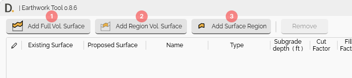
Image: Tool snapshot showing the different earthwork calculation types
Note: the version on the image may not reflect the latest version of DiCivil Package.
Basic Workflow
- Open Earthwork Tool - From the DiRoots tab.
- Choose Calculation Type - Add full volume or region volume.
- Select Surfaces - Choose existing and proposed/future surfaces.
- Configure Layers (optional) - Set up topsoil stripping and subgrade base layers.
- Execute Calculations - Run volume analysis.
- Review Results - Check cut/fill volumes and totals.
- Create Reports - Export data to Excel or create Civil3D tables.
 Note: the version on the image may not reflect the latest version of DiCivil Package.
Documentation Structure
This user guide is organized into the following sections:
- Calculations - Detailed explanation of calculation methods, parent and child region workflows, and totals description
- Layer Consideration - Topsoil stripping and subgrade base surface configuration and data storage
- Reporting - Excel export and AutoCAD table creation
- Additional Features - Context menus, selection tools, and workflow features